Romania Road Trip Planning Guide: Routes, Roads and Stays
Plan a romania road trip with suggested routes, rural road conditions, driving safety, EV charging notes and Transylvanian countryside stays.
Most Romania road trip plans start with a place list and a map, then assume a car will join the dots. The distances look manageable. Then the app quotes an arrival time that presumes a motorway the whole way, someone asks whether the mountain pass is open in the month you're travelling, and the last booking of the day sits two hours of unlit county road away from dinner.
A Romania road trip holds together better when you plan it by road class rather than by headline sights. Decide which legs run on motorway, which on national roads, which finish on a village lane, and how much daylight each one needs. Do that first and the itinerary mostly shapes itself.
The order that works: pick a route shape, check the class of road on every leg, build each day around a daylight arrival, then settle charging and accommodation before you fly.
Romania Road Trip Routes Compared
Four route shapes cover most Romania itineraries, and the useful difference between them is the road class under each leg. Choose the class first, then let the sights slot into days that end in daylight.
| Route | Regions linked | Main road type | Best suited for |
|---|---|---|---|
| Bucharest to Brașov and Sibiu corridor | Wallachia to central Transylvania | Motorway and major inter-city roads | First-time visitors and EV drivers needing fast-charging stops |
| Transfăgărășan crossing (DN7C) | Transylvania and Wallachia across the Făgăraș Mountains | Mountain road, seasonal access | Summer drivers seeking a scenic mountain crossing |
| Villages and foothills loop | Brașov and Covasna areas | County and village roads | Heritage visits and countryside stays |
| Carpathian foothill retreat | Rural Transylvania | Secondary roads | Quiet retreat stays with access confirmed beforehand |
The Bucharest to Brașov and Sibiu corridor is where driving behaves closest to a Western European itinerary. Motorway and major inter-city roads carry most of the distance, fuel and charging stops are frequent, and a tired arrival on an evening flight can still be in Brașov the same night. It suits a first visit and anyone who wants Transylvania delivered without a navigation puzzle.
The Transfăgărășan is the opposite proposition. DN7C crosses the Făgăraș Mountains on a seasonal mountain road, so treat it as a summer route. Sections have traditionally closed in winter for snow and avalanche risk, which means the pass has to be open on your dates before you build a trip around it.
A villages and foothills loop through the Brașov and Covasna areas runs on county and village roads, and it rewards shorter hops over mileage. The draw is local: fortified churches, Szekler villages, small museums and restored houses to sleep in. Miklósvár Castle, the Count Kálnoky venue in Covasna County, sits within easy reach of both Brașov and Sfântu Gheorghe, so it works as a stop on this loop rather than a separate expedition.
The fourth shape is a single foothill retreat reached by secondary roads. Less driving, more time on foot, and the last few kilometres decide whether the car you rented is the right one. Ask where the surfaced road ends, whether the final stretch is steep or unlit, and confirm the approach and arrival arrangements with the property before you commit.
For three or four days, take one shape and one base. For a full week, pair the corridor with either the mountain crossing or a two-base version of the villages loop, and resist adding a third region. A slower local base is a complete plan in its own right.
Road Types and What They Mean for Your Route
Romania's public road network ran to 86,847 km in 2024, including 17,994 km of national roads, 35,091 km of county roads and 33,762 km of communal roads, according to INS figures reported by ActMedia. Those classes aren't interchangeable. The class is what tells you how long a leg really takes.
| Road class | Length or share | Planning implication |
|---|---|---|
| National roads | 17,994 km | Links regions; condition varies by section, so check each leg |
| County roads | 35,091 km | Carries much rural access traffic; narrower and less consistently marked |
| Communal roads | 33,762 km | Serves villages; plan daylight arrival and check the surface first |
| Motorways | A small share of the network | Fast corridors that rarely reach rural destinations |
What the network split means for your route
Motorways cover only a small share of that total, and they run between cities rather than into the hills. Almost every rural destination in Transylvania is reached the same way: a fast corridor to the region, a national road into the valley, then a county or communal road for the last stretch. Plan each day in that order and the timings start to make sense.
County and communal roads together make up the bulk of the network, and they carry most rural access traffic on the narrowest, least consistently maintained surfaces. A communal road can be fresh asphalt for two kilometres and loose gravel for the next five, with the change marked by nothing more than a widening of the potholes.
What this means at the wheel: a national road can be smooth in one county and crumbling at the edges in the next. Judge the leg, not the label.
A line that looks short on the map usually runs through three or four villages, each with a low limit, a level crossing, farm machinery in season and a stretch where the asphalt gives way to patched gravel. That's why a 60-kilometre county-road leg can take well over an hour while a 140-kilometre motorway leg takes ninety minutes.
This is also the argument for a slower, locally based loop. Three days around one base in Covasna or the Brașov foothills shows you more of Transylvania than five days spent transferring between distant stops, and every leg stays on roads you've already checked.
Plan Each Driving Day and Drive Safely on Rural Roads
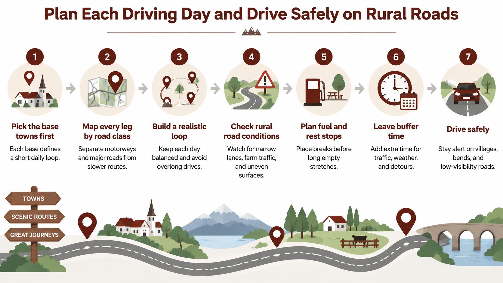
A Romanian driving day rewards design more than distance. Run the same seven checks on each one, whether the day is a motorway transfer or a village loop from a single base.
- Pick the base towns first. Each base defines a short daily loop, so you drive forty minutes to a village instead of three hours across a county. The usual slip is choosing accommodation on property quality alone, then discovering every morning starts with a long transfer.
- Map every leg by road class. Separate motorway and national road from county, communal and mountain road, because the class sets the speed you can hold. The slip is treating a 70-kilometre county leg as a 45-minute drive because the app says so.
- Set a daylight arrival for anything rural. Villages, farms and foothill properties are unlit, junctions are poorly marked, and a wrong turn costs more after dark. In winter that means planning around a short afternoon, so schedule rural arrivals for mid-afternoon rather than evening.
- Add buffer to every estimate. Low average speeds, agricultural traffic, livestock and weather all stretch a leg beyond the quoted time. Build the buffer into the plan rather than spending it in the dark.
- Check seasonal access before leaving. Mountain passes and unpaved approaches close or degrade with the weather, and torrential rain and flash floods affect mountain areas in spring and summer. The slip is trusting a route that was open last August.
- Choose the vehicle, maps and fuel for the worst leg. Adequate ground clearance, offline maps and a fuel reserve matter more than boot space on a rural itinerary.
- Confirm arrival details with the property. Parking, gates and the state of the final kilometre are the details worth settling in advance.
The habits that go with the plan
Romania recorded 78 road fatalities per million inhabitants in 2024, the highest rate in the EU against an EU average of 45, with infrastructure deficiencies, excessive speed and mixed traffic identified as contributing factors, and the country operates a zero-alcohol limit for all drivers, according to EU road-safety reporting. The practical translation is simple: set speed by sight distance, pavement quality, roadside activity and oncoming traffic, and treat the posted maximum as a ceiling you rarely reach.
Keep a generous following distance. Expect abrupt overtaking and slow-moving vehicles around the next bend. Avoid unlit secondary roads at night, where pedestrians, animals and cyclists appear later than you can react.
Daily test: can every leg end in daylight with time to spare? If not, cut a stop rather than a safety margin.
Daylight discipline and fatigue management decide more rural outcomes than vehicle choice, and BTOURS's guide to safe road tripping in the Nordics works through both in detail. If a riding day is part of the plan, the horse riding holiday planning notes cover how transfers and saddle time fit around driving legs.
For a sense of what these roads look like from behind the wheel, this short drive shows the mix of surfaces and settlement you'll meet:
Charging an Electric Car on Romanian Routes
You turn off the Bucharest to Brașov and Sibiu corridor onto a county road, and the rest of the day is limited by the last fast charger, not by the village on the map. An electric car is practical on that motorway and national-road spine. Shift the itinerary onto rural roads and the schedule has to get conservative.
Romania's charging network grew by 33% year on year to just over 4,500 charging points in 2025, and a major A1 motorway hub opened with 34 fast-charging points, according to the Roland Berger EV Charging Index insight for Romania.
Those points sit on the main corridor. Public charging is still widely seen as thin, and charge times often feel slow. A slower itinerary based in one place handles that limit: short legs out, and the same charger to come back to. A long loop on county roads is where range runs out.
Checks before leaving the main corridor
- Plan the last charging stop deliberately. Identify the final fast charger on the motorway or national road before you turn onto county roads, and treat everything beyond it as your return range.
- Keep a range buffer for elevation and cold weather. Climbing into the foothills costs more than the distance suggests, and winter reduces usable range further.
- Ask each property about charging, and treat an unconfirmed answer as no. Don't assume a rural guesthouse has a usable socket for a car.
- Carry a petrol or hybrid fallback mentality. If the itinerary depends on remote legs, a conventional or hybrid rental removes the risk entirely.
If a host mentions a wall box, compare it with a best ev charger before you treat overnight charging as part of the plan. A household socket and a proper unit do not give you the same morning range.
Charging on rural Transylvania roads is a question to settle with each property before departure, not something to improvise on arrival.
Cultural Stops and Stays in Transylvania
The drives that matter most here are the short ones off the main road. Miklósvár Castle stands in Micloșoara, Covasna County, and the estate's Miklósvár Castle events page presents it as a castle-wedding and private-event venue, with driving directions from both Brașov and Sfântu Gheorghe given as approximately 45 minutes by car each way. That puts it within a day's loop of either city, but the final stretch runs on county and village roads rather than the national network, so allow more time than the distance alone suggests. Basing yourself in the village and making day trips from one stay is a workable alternative to moving hotels every night.
Castle events and village stays are booked separately
The same page distinguishes the castle from the village guesthouses, and the distinction matters when you're planning. An event booking at the castle doesn't automatically include accommodation inside it. Guests enquire about the village guesthouses separately, and the traditional, cottage-style rooms in Miklósvár and Micloșoara are the usual base for a rural stay.
Before you go: ask which spaces are open to visitors, whether the property is hosting an event on your dates, and what access looks like on the day.
Kőröspatak Castle in Valea Crișului is the second venue, with its own visiting arrangements and available spaces confirmed by the team through the Kőröspatak Castle events page.
| Stop or stay | Location | What it offers | Confirm before you go |
|---|---|---|---|
| Miklósvár Castle | Micloșoara, Covasna County | Castle-wedding and private-event venue, about 45 minutes from Brașov and Sfântu Gheorghe | Which spaces are open to visitors and access details |
| Kőröspatak Castle | Valea Crișului | Event venue listed on kalnoky.ro | Visiting arrangements and available spaces |
| Village guesthouses | Miklósvár and Micloșoara | Guesthouse accommodation, separate from the castle | Current availability on transylvaniancastle.com |
| King's Retreat | Zalánpatak or Valea Zălanului | Carpathian foothill stay | Exact access route and arrival arrangements, to confirm with the team |
The King's Retreat sits in the Carpathian foothills at Zalánpatak, and its access is the kind of detail worth settling before you drive there rather than after. For guesthouse availability and countryside stays, the Count Kálnoky guesthouses are listed and booked through the main site.
Confirm Your Stay Before You Set Off
Choose a route shape, check the road class and daylight arrival for every leg, and settle charging or fallback fuel before you leave. Then confirm the accommodation side, because that's where rural itineraries most often come apart.
Accommodation, riding holidays and countryside stays are handled on transylvaniancastle.com. Weddings and private events run through a separate team: start at the events pages on kalnoky.ro, with venue details for Miklósvár and Kőröspatak, and enquiries through the event enquiry form. Public concerts are listed separately in the events calendar.
Prices, availability, access, pet rules and inclusions aren't published here, so ask the team directly and request a personal offer for events. If you're weighing up a town hotel against a village base, these notes on Transylvania hotels and rural stays set out the trade-off.
Send these five questions before you travel:
- Arrival time: what time should we aim to reach the property in daylight?
- Parking: where do we leave the car, and is the final approach paved?
- Charging: is there a usable charge point for an electric car?
- Accommodation spaces: which rooms or cottages are available on our dates?
- Access details: gates, keys and who to call if we're running late.
Count Kálnoky's Estates is the base most of these itineraries end up needing: restored heritage guesthouses in Miklósvár and Micloșoara, riding holidays on the estate's Lipizzaners and Shagya Arabians, and a foothill retreat at Zalánpatak, all positioned for the county and village roads this guide describes. If your trip is a celebration rather than a holiday, the castle venues at Micloșoara and Valea Crișului are booked through the events team on kalnoky.ro. Start with Count Kálnoky's Estates, tell the team which route shape you're considering, and ask them to confirm access, arrival times and availability for your dates.